

2017’s Warming Climate Produces Unprecedented Floods Across the Globe
“A
robust result, consistent across climate model
projections, is that higher precipitationextremes in
warmer climates are very
likely to
occur.”
— IPCC
“As
the climate has warmed… heat waves are longer and hotter. Heavy
rains and flooding are more frequent. In a wide swing between
extremes, drought, too, is more intense and more widespread.”
*****
10
April, 2017
It’s
a tough fact to get one’s head around. But
a warming climate means that many regions will both experience more
extreme droughts and more
extreme floods.
The cause for this new weather severity is that a warming planet
produces higher rates of evaporation together with more intense
atmospheric convection. Warmer air over land means that the moisture
gets baked out of terrain, lakes and rivers faster. And this warming
effect causes droughts to settle in more rapidly, to become more
intense than we are used to, and to often last for longer periods.
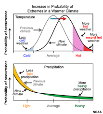
(As
the climate warms, instances of extreme weather — both droughts and
floods — increase. Image source: NOAA/UCAR.)
On
the flip side of this severe weather coin, more moisture evaporating
from the world’s lands and oceans means that the atmosphere
contains a greater volume of moisture overall. This heavier moisture
load enters a hotter, thicker, taller lower atmosphere (troposphere).
One that is becoming increasingly stingy about giving up that
moisture in the form of precipitation much of the time. All that heat
and added convective energy just serves as a big moisture trap. So
the load of moisture has to be heavier, overall, to fall out. When
the atmospheric moisture hoarding finally relents, it does so with a
vengeance. Thicker clouds with higher tops drench lands and seas with
heavier volumes of rain and snow. And when the rain does fall from
these larger storms, it tends to come, more and more often, in
torrents.
California
Record Drought to Record Flood in Just 4 Years
A
set of facts that were drawn into stark relief recently in California
which over the past few years experienced
one of its driest periods on record but,
in 2017, is on tap to see its wettest year ever recorded for broad
regions. In a section of hard-hit Northern California, the cumulative
2017 rainfall average had, as of yesterday (April 9), hit 87.5
inches. The record for the region in all of the past 122 years is
88.5 inches for the entire year.

(Cumulative
precipitation in Northern California set to beat all time record
during 2017. Data Source: California
Department of Water Resources.
Image source: The
Sacramento Bee.)
It
is just early April. But the region tends to receive most of its
moisture from January through March. However, all it would take is a
relatively minor storm system to tip the scales into record
territory. And it now appears likely that this region will see in
excess of 90 inches for the present year.
Infrastructure
damage from this year’s flood for the state is likely to
considerably exceed $1 billion. Damage
to roads alone is nearly $700 million. And that does not include
stresses to dams — like the one at Lake Oroville where an eroded
spillway threatened structural integrity and forced 200,000 people to
evacuate.
New
Zealand — Debbie Brings 500 Year Flood Event with More to Follow
In
New Zealand, a Tropical Storm Debbie (which struck Australia as a
Category 4 Hurricane and flooded
1,800 homes in the town of Rockhampton)
engorged with the extraordinarily high volume of moisture evaporating
from the very warm waters of the Pacific Ocean produced a rain event
that, under normal climate conditions, would have occurred only once
every 500 years. The storm blanketed much of New Zealand with strong
winds and heavy rains — sparking flooding and power outages. On
North Island, the system hit a new extreme as it dumped
a record two months worth of rain (7.5 inches) in just two days upon
the town of Edgecumbe.
The torrent swelled the nearby Rangitaiki River, forced a levee
breach, flooded the city, and spurred thousands
of residents to evacuate.

(Cyclone
Cook takes aim at New Zealand and a link-up with a trough dipping
through the region. Image source: LANCE-MODIS.)
Across
New Zealand, flooding damage estimates from the event are expected to
considerably exceed 1 billion dollars and
could track into the billions.
Meanwhile,
Cyclone Cook, similarly engorged with moisture, is in the process of
combining with a large trough extending down from the Southern Ocean
and over New Zealand. Cook is predicted to track toward New Zealand
across ocean waters that are 1-2 C warmer than normal over the next
few days. It is expected to feed energy into a long frontal system
extending up from the ocean region just north of Antarctica. Present
model predictions indicate the potential for extremely high cloud
moisture loading in
the range of 3.5 kilograms of water per square meter over parts of
North Island near Tauranga in the 26-30 hour time-frame. A worrisome
potential extreme precipitation hot spot in a mated
system that is expected to again blanket New Zealand with flooding
rains over the next three days.
Peru,
Colombia, Ecuador Floods
In
isolation, each of these extreme events would be odd enough. But
right now the issue is that the heightened frequency and widespread
geographic dispersal of extreme flooding is a considerable concern.
And to this trend of more widespread incidents, we can add the
extraordinarily severe flooding that has impacted several South
American nations during early 2017.
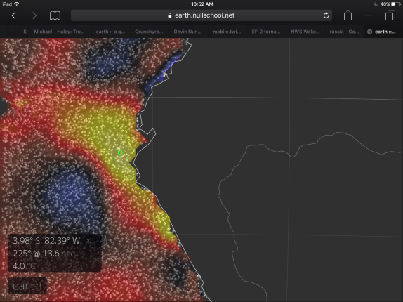
(Strong
El Nino events are often associated with flooding in western South
America. Though an El Nino is expected during 2017, it is predicted
to be weak-to-moderate in intensity. So it is likely that the very
warm waters feeding extreme rains in the region were given an assist
by human-forced climate change. Image source: Earth
Nullschool.)
Very
warm sea surface temperatures off South America this winter and
spring have fed into record rains across Peru, Ecuador and Columbia.
In Peru, what was arguably the worst flooding ever recorded for the
state during March destroyed tens of thousands of buildings,rendered
700,000 people homeless,
resulted in the loss of about 100 souls, and wrecked 6,000 miles of
highway and scores of bridges. The number of people made homeless by
this single series of extreme weather events is particularly
staggering — amounting to about 1 out of every 40 people living in
the state. For Peru alone, an
estimated 9 billion dollars is now needed to recover.
Nearby
Ecuador also experienced record rains. Tens
of thousands of acres flooded as 20 people lost their lives and
thousands of people were forced to evacuate. And
in the Colombian town of Macoa near the Ecuador border, a
severe, rain-bomb type, thunderstorm associated with this
extraordinarily moist weather pattern unleashed mudslides and
torrents of water so violent that 254 victims were unable to escape.
Conditions
in Context
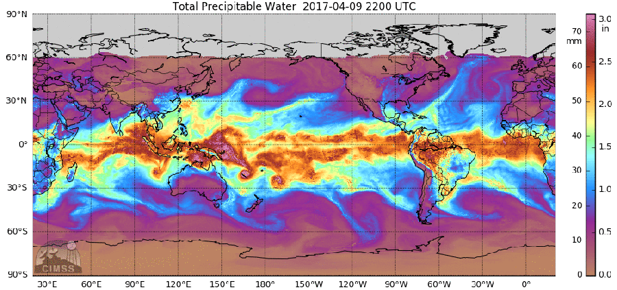
(Atmospheric
rivers are often associated with extreme rainfall events as was the
case with California this winter and spring. Global water vapor
tracking enables us to track these atmospheric rivers streaming out
from the moisture-rich Equatorial region. Image source:CIMSS.)
It
is worth noting that each of these instances of severe rainfall
around the globe rank as either the worst on record or nearly the
worst on record for the impacted regions. They occur in a similar
temporal space but over a widely varied geographical extent. In the
instance of apparent cyclone flooding amplification in Australia and
New Zealand — very warm and above average sea surface temperatures
appear to have been involved. This is also the case with the severe
rains seen in South America. In California, a shift in the weather
pattern from extremely dry to extremely wet followed a receding of
hot ocean conditions and an associated blocking
pattern.
The warm Pacific waters which pushed storms north into Alaska and
Canada instead shifted to a cool-north, warm-south pattern that
intensified the storm track and enabled the direction of record high
atmospheric moisture plumes near the Equator toward California. All
of these various patterns are consistent with what we would expect
from a human-forced warming of our climate.
Links:
Hat
tip to Vic
Hat
tip to Climatehawk
No comments:
Post a Comment
Note: only a member of this blog may post a comment.