

Warm Arctic Storm Tearing Sea Ice to Shreds amidst Big 2016 Heat Spike
19
August, 2016
Abnormal.
Unprecedented. Remarkable. Extreme. These words are supposed to
describe unusual events, but in the weird world we’re now entering,
the extreme has become commonplace. Some people call this emerging
state of affairs ‘the new normal.’ A more direct descriptor is
‘spiraling into climate chaos.’
Chaos is
an apt word to describe the scene in the Arctic this week as one of
the most powerful summer cyclones ever to form rages in a place that
has just experienced a record-shattering influx of atmospheric heat.
This storm is hammering the sea ice, pushing it nearly to the
second-lowest extent on record. But worse may be still to come as a
very weak and diffuse ice pack is predicted to face off against a
storm that’s
expected to significantly reintensify on both Friday and Tuesday.
Record
Arctic Heat
The
Arctic. It’s a place we typically associate with frozen things. Due
to the billions and billions of tons of heat-trapping gasses dumped
into the atmosphere each year by burning fossil fuels, now it’s a
place that’s thawing at a disturbingly fast pace. The region could
best be described in these few words — record
abnormal warmth in
2016.
(This
graphic from University of California, Irvine Ph.D. candidate Zack
Labe is
a visual measure of a stunning jump in Arctic temperatures for 2016.
So much heat in the Arctic has profound implications, not just for
the Arctic ice and environment, but for the rest of the world as
well. In other words — warming that happens in the Arctic doesn’t
stay in the Arctic.)
So
far, 2016 has seen temperatures in the Arctic that are well above the
warmest previous year ever recorded. This big spike in a decades-long
trend includes, for this single year, about 35 percent of all the
temperature rise experienced there since the late 1940s. It’s like
taking more than a third of all the warming in the Arctic seen over
the past 68 years and cramming it into just one year. It’s insane.
The
Warm Storm Generator
Heat
in the Arctic doesn’t just emerge there. It comes, largely, in the
form of energy transfer.
Heat-trapping
gasses warm the atmosphere in an uneven fashion. The way these gasses
absorb solar radiation results in more heat trapping during the dark
of night. And the Arctic experiences a thing called polar
night which
lasts for months.
As
a result, the Arctic already gets a slightly more powerful nudge from
global warming than the rest of the world. As the cold begins to fail
in the Arctic, a number of amplifying feedbacks come into play that
further multiply the warmth.
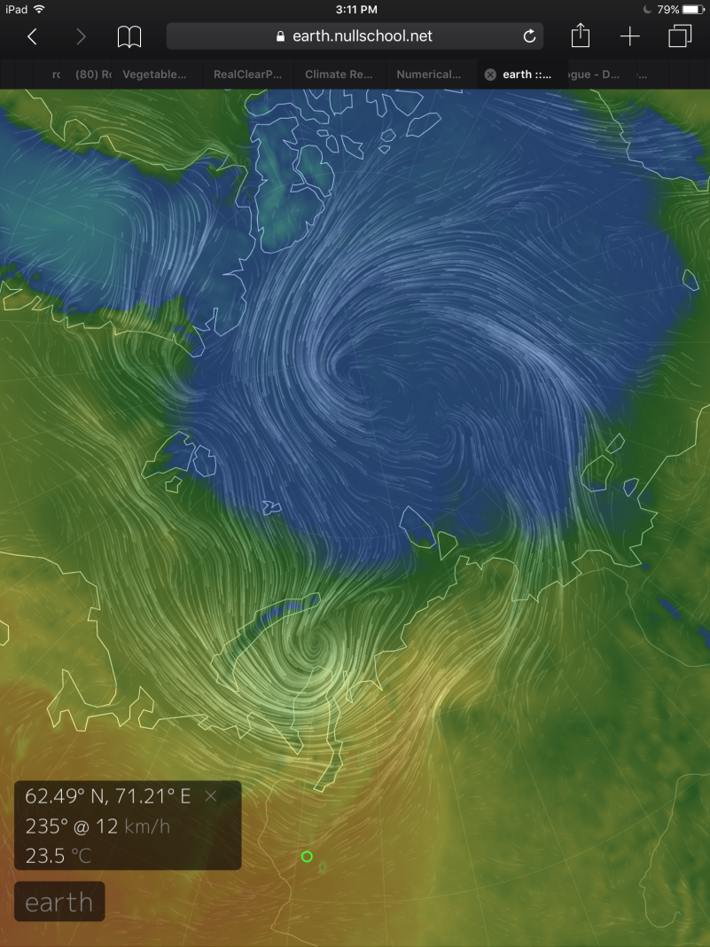
(A
dance of cyclones.
GFS model rendering by Earth
Nullschool shows
a strong influx of heat from the Eurasian Continent and the Barents
and Kara Seas feeding into a bombing low-pressure system on Monday at
12:00 UTC. The low is predicted to meet up with the currently raging
Arctic cyclone by late Monday or early Tuesday. Combined, these lows
are expected to drop into the 960s to 970s mb level, extending the
scope of the strong event and possibly resulting in the most powerful
cyclone ever to have formed this time of year in the Arctic Basin.
Image source: Earth
Nullschool.)
As
the Arctic heats up, its natural barriers to heat coming up from the
ocean or from the south begin to fail. The more evenly-warmed surface
of the ocean transfers some of its heat north and pumps this added
energy into the Arctic air. The lower sea-ice levels cause this water
to warm even more, its
dark surface trapping more of the summer sun’s warmth than the
white ice ever could.
The
polar Jet Stream begins to weaken as the relative difference between
Arctic and lower-latitude temperatures drops.
In the Jet Stream’s meanders, strong warm winds blow in from the
ever-hotter continents and ocean surfaces of the mid and upper
latitudes.
It’s
a simple physical property of the atmosphere that burgeoning heat
often seeks out the cold. It rises as it flows toward the Pole, and
when it collides with these chilly pockets, the result can be an
atmospheric maelstrom.
The
Great Arctic Cyclone of 2016 Smashes Sea Ice
Such
was the case earlier this week as
a warm tongue of air flowed up into area of the Laptev Sea from
Siberia. This warm flow tapped moisture from the Kara and Barents
Seas and fed into a developing storm system (see
article here).
Pressures at the storm’s center rapidly fell and
by late Monday, August 15th, had dropped to 966.5 millibars.
The result was one of the strongest cyclones ever to form over the
Arctic Ocean during August.
(We’ve
probably never seen the ice so thin near the Pole during August. Zack
Labe‘s
rendering of SSMIS sea ice concentration measures from late July
to August 17 shows a stunning degree of thinning and loss. Note the
large, low-concentration holes opening up near the Pole in the final
few frames.)
The
storm rampaged through the Arctic. Pulling in strong winds and heavy
surf, it smashed the sea ice, driving
daily extent losses to 110,000 square kilometers on Tuesday and
greatly thinning a vulnerable tongue of ice running out toward the
Chukchi Sea. Meanwhile, near the Pole, great gaps 50 to 100 miles
wide have opened up, revealing water that is 80 percent clear of ice.
The
storm subsequently weakened, with pressures rising today into the 985
mb range. But over the next few days, the system is predicted to
reintensify — first on Friday to around 971 to 978 mb as it
approaches the Canadian Arctic Archipelago, and then again on Tuesday
to around 963 to 976 mb when it loops back toward the Laptev.
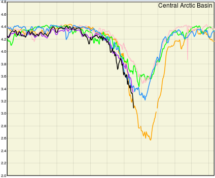
(AMSR2
and SSMIS sensor reanalysis shows
that 2016 Arctic sea ice area [black line] in the Central Arctic
Basin — a key region for indicating sea ice health — hit new
record lows over recent days. A signal that a challenge to 2012
records could emerge over the coming days as the 2016 cyclone is
expected to re-intensify. Image source: The
Great White Con.)
In
each case, the storm is predicted to draw on heat, moisture, and
low-pressure cells riding up from the south, with the first stream of
energy feeding into this low from over the Beaufort and Bering Seas
and northeastern Siberia, and the second running up from the Barents
and Kara Seas, western Siberia and northeastern Europe (you can see
the succession of lows and moisture here
in this model run by Climate Reanalyzer).
If
this happens, we’ll be coming out of a situation where a
warmth-fueled Arctic cyclone will have bombed to record or
near-record strength on two to three separate occasions, all the
while applying its buzz-saw winds, waves and Coriolis forces to the
sea ice — a full-blown nightmare Arctic sea-ice melt scenario in
the midst of a record-hot year.
Links:
Hat
tip to DT Lange
Hat
tip to Colorado Bob
Hat
tip to Bill h
No comments:
Post a Comment
Note: only a member of this blog may post a comment.